| View previous topic :: View next topic |
| Author |
Message |
williambutler
Finger Mullet
Joined: 27 Jun 2006
Posts: 35
Location: Red Neck Riveara!
|
 Posted: Sun Jul 23, 2006 8:52 am Post subject: Still haven't gottin accurate info on PINS driving Posted: Sun Jul 23, 2006 8:52 am Post subject: Still haven't gottin accurate info on PINS driving |
 |
|
Please,
Someone, is there a map of the areas that are legally accessible
BY vehicle.
Would like to go as a large group WAY down there for a weekend
get away without breaking laws or being harassed.
_________________
SAVE YOUR BEACH TEXAS!
CHECK OUT THESE SONGS, linked below!
http://www.myspace.com/dickyneely |
|
| Back to top |
|
 |
rabbit
Full Grown Flour Bluffian

Joined: 06 Mar 2006
Posts: 3835
Location: FLOUR BLUFF
|
| Posted: Sun Jul 23, 2006 8:59 am Post subject: |
|
|
If you have 4 wheel drive you can go to the PINS and drive almost 60 miles to the mansfied jetties.
_________________
Fishing and Kayaking its a rough life but somebody has to do it. |
|
| Back to top |
|
|
Tarzan
Member White Shrimper Boot Club

Joined: 07 Mar 2006
Posts: 675
Location: ICU
|
| Posted: Sun Jul 23, 2006 9:18 am Post subject: |
|
|
Hey Will, like I said before.... You can get on the sand just past the pavillion and drive to the Mansfield jetties(I say 63 miles-some say 60 miles). There is a road back to Yarboro pass just before the 15, there is a back road that is legal to drive on from the 18 to the 28(or so), and there is a road that runs along the north side of the north jetty at Mansfield. I have only been about 1/4 mile down the jetty road but you can go more than that if you don't mind driving through the wet muck. I wouldnt do it alone with the mosquitos. It could be a pretty nasty walk back to the beach.
THAT IS IT!!!!!!
Anywhere else you may see a road or what may look like a road into the dunes is NOT legal to drive on!!!!!!!
later,
Ernie
P.S. How did you like dinner at Waterstreet with my Aunt last night HAHAHA! Did you need a few drinks to make it through...LOL |
|
| Back to top |
|
|
TTRR
Horse Mullet

Joined: 18 Apr 2006
Posts: 115
Location: Corpus
|
| Posted: Sun Jul 23, 2006 9:27 am Post subject: |
|
|
| i have a basic map up on my website www.thetexassharkcompany.com. go to the surf fishing link and scroll down. |
|
| Back to top |
|
|
williambutler
Finger Mullet
Joined: 27 Jun 2006
Posts: 35
Location: Red Neck Riveara!
|
| Posted: Sun Jul 23, 2006 11:59 am Post subject: |
|
|
Thanks for the map!
Can you add stuff to it?
Where are the roads / passes through the dunes?
exe: "just past the pavillion (I say 63 miles-some say 60 miles)."
Sounds really spooky like a legend or myth.
-------------
Dinner was great! The aunt on the other hand was pretty wild to
deal with. It was pretty funny to get the posh NewYorker in and out
of my truck, then had to get a jump start in the middle of Water street.
_________________
SAVE YOUR BEACH TEXAS!
CHECK OUT THESE SONGS, linked below!
http://www.myspace.com/dickyneely |
|
| Back to top |
|
|
Tarzan
Member White Shrimper Boot Club
Joined: 07 Mar 2006
Posts: 675
Location: ICU
|
| Posted: Sun Jul 23, 2006 12:20 pm Post subject: |
|
|
Will, why are you still home? My rods are loaded and I'm headed to NPJ. Bring your punkystick...
and some beer...
later,
Ernie |
|
| Back to top |
|
|
Texmaps
Horse Mullet
Joined: 14 Mar 2006
Posts: 190
Location: Oso Bay
|
| Posted: Sun Jul 23, 2006 12:52 pm Post subject: |
|
|
| TTRR, I dont mind you using my map but you should give me credit for it on your website. |
|
| Back to top |
|
|
williambutler
Finger Mullet
Joined: 27 Jun 2006
Posts: 35
Location: Red Neck Riveara!
|
| Posted: Sun Jul 23, 2006 2:41 pm Post subject: |
|
|
Don't have websight, not posting this anywhere else.
Wish it was more detailed!
I'm still interested in more maps of the area.
_________________
SAVE YOUR BEACH TEXAS!
CHECK OUT THESE SONGS, linked below!
http://www.myspace.com/dickyneely |
|
| Back to top |
|
|
Tarzan
Member White Shrimper Boot Club
Joined: 07 Mar 2006
Posts: 675
Location: ICU
|
| Posted: Sun Jul 23, 2006 7:40 pm Post subject: |
|
|
Will, where were you? Anyway, the Texmap guy isn't talking to you and if so just ignore. Geez, that is the weakest PINS map I've ever seen. Cheap copy of the one they hand out for free at the gate. I wonder how much money I could make if I copied all the maps I have saved over the years.
Not to nail Texmaps but geez dude....
later,
Ernie |
|
| Back to top |
|
|
Tarzan
Member White Shrimper Boot Club
Joined: 07 Mar 2006
Posts: 675
Location: ICU
|
| Posted: Sun Jul 23, 2006 7:44 pm Post subject: |
|
|
Anyway, that got me off the subject...guess you're back to Fredtown..quick NPJ report..no fish, lot's of beer and BBQ, & fat bottomed girls.
later,
Ernie
P.S. Email me your new cell! |
|
| Back to top |
|
|
Texmaps
Horse Mullet
Joined: 14 Mar 2006
Posts: 190
Location: Oso Bay
|
| Posted: Sun Jul 23, 2006 8:12 pm Post subject: |
|
|
 |
|
| Back to top |
|
|
obsessed
Full Grown Flour Bluffian

Joined: 08 Mar 2006
Posts: 1200
|
| Posted: Sun Jul 23, 2006 8:54 pm Post subject: |
|
|
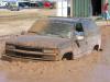
there ain't much too it, all you can do is drive down the beach south till you hit the Mansfield Jetty, like Rabbit said....
there is a road, but IMO, there hasn't been a lot of rain down there, so it is going to be soft, really soft.....just drive down the beach till you find a nice hole...
good luck..
Nice map Texmaps.....
_________________
Trophy whitetail and exotic hunts on some of the finest ranches Texas has to offer, www.mcoutfitterstexas.com
www.baffinbayrodandgun.com |
|
| Back to top |
|
|
Tarzan
Member White Shrimper Boot Club
Joined: 07 Mar 2006
Posts: 675
Location: ICU
|
| Posted: Mon Jul 24, 2006 3:07 pm Post subject: |
|
|
Wow, that is an awesome map. I bought one of those at Zadansky Map Store about two years ago. I didn't realize it was published by Texmaps. I think I paid like $4.00 for it. Well worth the bucks. I also have a map that came with a book I bought from the National Seashore years ago that is super detailed and shows all of the back roads and the old cattle camps. A very interesting thing I found when comparing the A&M Geology map and the Treasure map is that on the A&M map, they show triangulation stations with codenames very close to areas on the treasure map, even one near the 48 mm where the Indian camp used to be. Many years ago, I used to see this old man in a big Dodge parked between the 47 and 48 mm and he was there every weekend but never fished. A few times I would see him walking in and out of the dunes. I bet he figured out where the camp was and was digging! I personally would love to hike back in the dunes near the 41mm where the old ship skeleton is. I have heard that a Brittish guy we know has the GPS to it, but that could be a rumor....
later,
Ernie |
|
| Back to top |
|
|
TTRR
Horse Mullet
Joined: 18 Apr 2006
Posts: 115
Location: Corpus
|
| Posted: Mon Jul 24, 2006 6:55 pm Post subject: |
|
|
| Texmaps wrote: | | TTRR, I dont mind you using my map but you should give me credit for it on your website. |
check your pm's |
|
| Back to top |
|
|
Big John
Full Grown Flour Bluffian

Joined: 07 Mar 2006
Posts: 2647
|
| Posted: Mon Jul 24, 2006 7:26 pm Post subject: |
|
|
| TTRR wrote: | | Texmaps wrote: | | TTRR, I dont mind you using my map but you should give me credit for it on your website. |
check your pm's |
Oooooooooooooo, looks like a slap fight. 
_________________
GOBZA!!!
 Save $$$ - Get Coupons local businesses today! - http://www.gobza.com/29472 Save $$$ - Get Coupons local businesses today! - http://www.gobza.com/29472 |
|
| Back to top |
|
|
|

